TRANSEURASIAN
Related : Paris Metro Map 2030
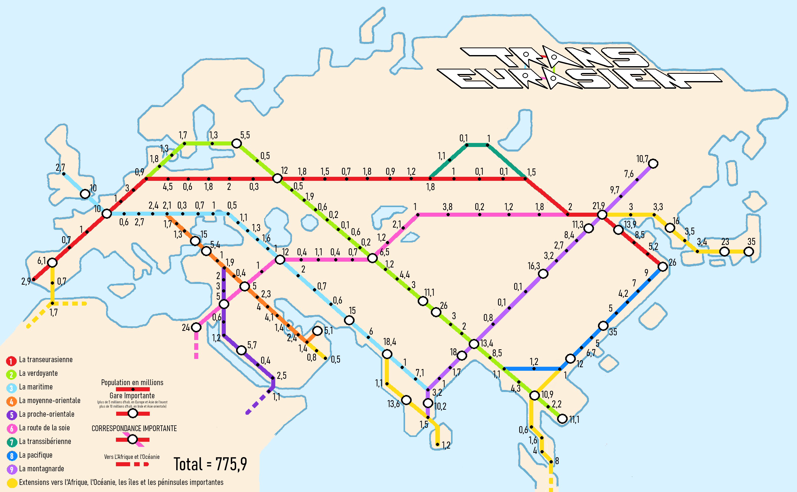
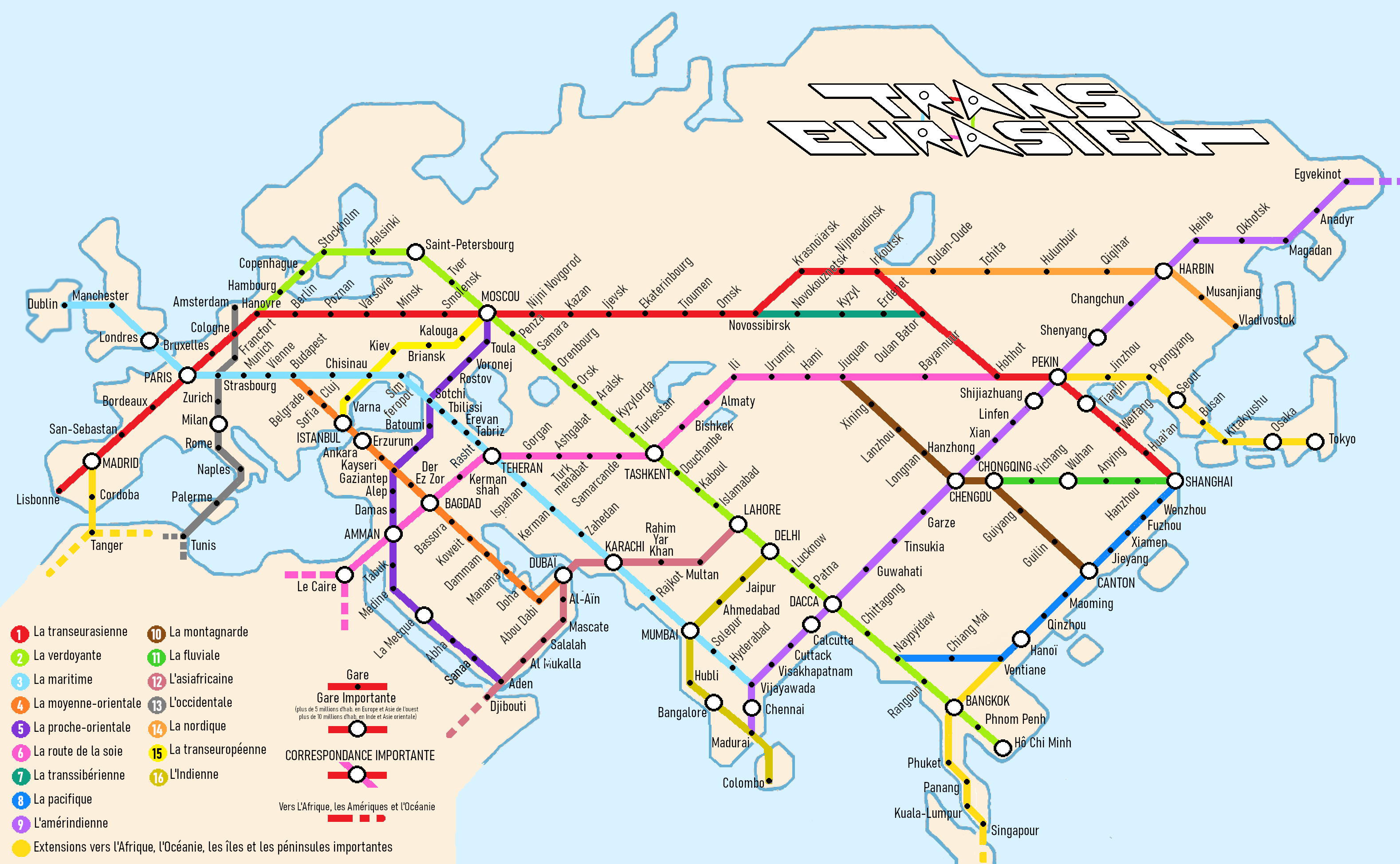
Core Transeurasian Network
THE TRANSEURASIAN
The Transeurasian is a proposed land network designed to efficiently and cost-effectively connect Eurasia within itself, to nearby islands, and to other continents. It organizes the major economic and demographic corridors of Eurasia into a network.
This Transeurasian network is presented in two versions: one called “basic” and another “developed,” represented using various types of maps for each version. For better readability, it often takes on the appearance of a railway or metro network. However, it applies to all types of land transportation—whether rail, road, highway, or others—both existing and planned.
The Transeurasian is
also an invitation to view the world differently and a playful way to approach global geopolitical issues. It highlights Eurasia’s central role in human geography.
It suggests that the world’s order depends on the situation in Eurasia. A peaceful and cooperative Eurasia could shift the world’s structure from a maritime organization to a land-based one.
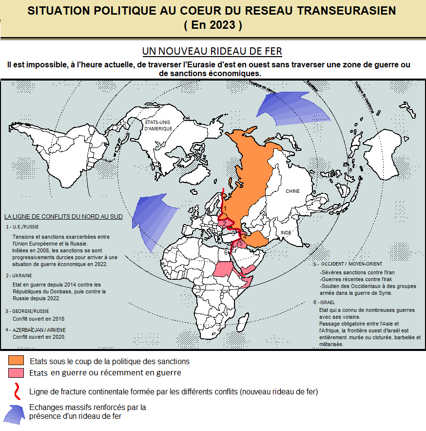
The logical dimension of the economic and demographic corridors forming this network contrasts with the political and ideological situation. To those familiar with the current political context, this network might initially appear fanciful, especially given connections such as a land link between the two Koreas, between Russia and Ukraine, or between China and the United States. However, further analysis tends to demonstrate that the real fantasy lies, conversely, in the current political and ideological context, which too often limits our thinking.
By extension, the Transeurasian raises awareness of the need and urgency for peace as well as openness to others through mutual respect. It is a great and noble challenge for current generations.
GENERAL DESCRIPTION
Network Structure
The network features rectilinear, relevant, and natural routes structured around the major axes connecting the three largest demographic hubs of the world : Western Europe, the Indian Peninsula, and the Far East.
The network is complemented by routes to the arabian and southeast asian peninsulas, naturally extending towards Africa in its initial stage, and later to Oceania and the Americas in its developed version. These extensions would make Eurasia the heart of a global land network.
The lines thus formed naturally intersect in major metropolises, which are likely to experience significant growth in the medium to long term.
Graphical Aspects
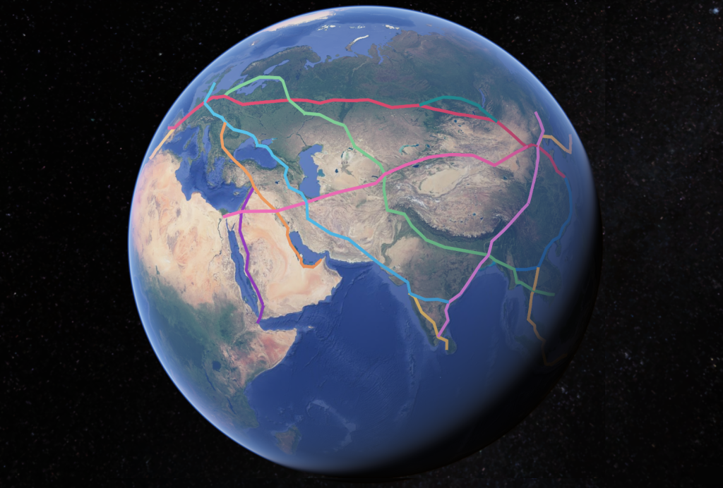
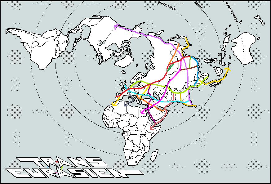
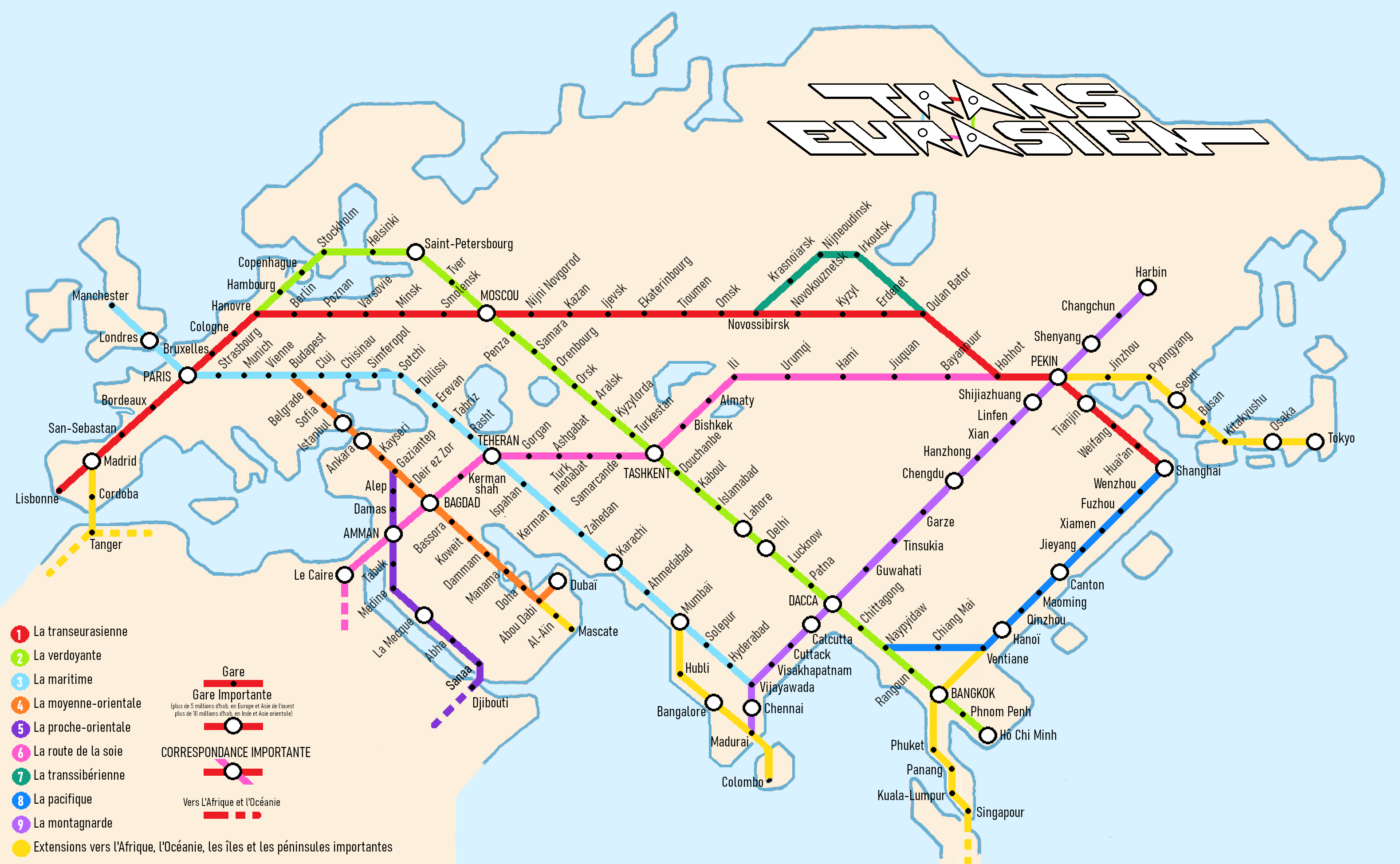
The Transeurasian network is represented through various types of maps in two versions: the “basic” version with the structural lines, and the “developed” version that completes the network.
– It often takes on the schematic appearance of a global metro map to maximize readability and to facilitate its adoption. The playful aspect of this choice does not detract from the seriousness of the presented network. Quite the opposite: while a traditional metro map emphasizes straight lines and smooths irregular gaps between stations, this metro-style representation distorts the very rectilinear routes and the otherwise regular intervals between stations.
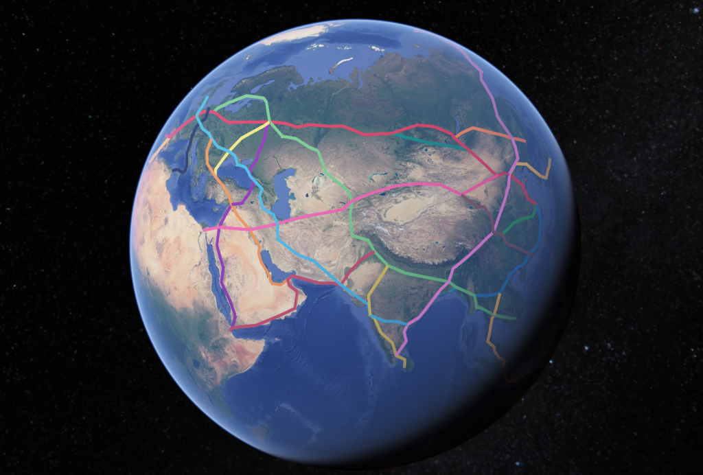
– A representation of the network on a globe highlights the rectilinear nature of the routes. However, given the network’s vastness, this map struggles to represent its extremities.
– The third type of map is a representation on a planisphere with the North Pole at its center. This view emphasizes the inhabited continents (i.e., all except Antarctica). It also highlights the geopolitical and geostrategic dimension of the Transeurasian as the central node of the human world.
Some Figures
The Transeurasian network connects 775 million people* near 160 stations in its basic version, with approximately one station every 400 km.
It serves 51 capitals across the 56 countries it spans and crosses 37 out of 41 continental Asian countries.
The philosophy of Trans-Eurasian
Trans-Eurasianism is built on a few simple observations and ideas:
Humanity should focus on itself, on where it is. Today, about 70% of the world’s population lives in Eurasia.
The wars and sanctions that divide Eurasia and cut it off from Africa must come to an end.
A peaceful Eurasia would create a world centered on land-based trade rather than maritime routes.
Beyond peace, mutual respect—even friendship—between nations is essential. Infrastructure like this naturally encourages cooperation and fosters lasting, beneficial relationships among all who share and benefit from it, directly or indirectly.
Thoughtfully designed, long-lasting infrastructure is one of the most valuable (or least harmful) legacies we can leave for future generations.
A vision for the future
Trans-Eurasianism envisions a continent free from wars, sanctions, and blockades—a place where national sovereignty is respected, regardless of ideology, religion, culture, or the political views of its people and leaders. A continent that refocuses on itself and its role in the world, recognizes its geographical unity, and naturally emerges—humbly but undeniably—as the heart of human civilization.
Developed Transeurasian network.
The Transeurasian vision promotes possible exchanges, not excessive trade. It values exchanges that enrich through blending, rather than those that erase and destroy. It supports exchanges that directly benefit the greatest number of people and, indirectly, everyone.
This applies to all forms of land-based exchange, whether of goods or people, from the slowest to the fastest—whether it’s transport by donkeys and wheelbarrows or a vehicle traveling several times the speed of sound.
As part of the peace it advocates, the Transeurasian naturally embraces differences, different languages and cultures, different religions and civilizations, with humility and openness, in their entirety and without hierarchy.
Developped network represented on a globe
Variations
Like any major road project, the Transeurasian plan includes alternative routes that are not shown here for clarity. Keen observers may notice slight differences in the routes between the core and expanded versions, revealing some of these possible variations. Certain segments will require in-depth studies to determine their final paths. Readers should not focus too much on the specific routes presented here, nor on the number of stops or the regularity of intervals between them.
The Transeurasian project and other major initiatives
There are three major road network projects in Eurasia—one led by China, one by Western Europe, and one by the United States. Compared to the Transeurasian project, these initiatives are more limited, both geographically and politically.
Build Back Better World (United States)
- The U.S. project does not aim to connect the largest possible portion of Eurasia’s population. On the contrary, it deliberately excludes key nations such as China, Russia, and Iran. This approach runs counter to the principles of Trans-Eurasianism, which is fundamentally about unity, whereas Build Back Better World is designed to divide.
Global Gateway (European Union)
- The Western European project is quite limited in scope, focusing only on Western and Central Europe while carefully avoiding Russia and Belarus for political reasons, despite the clear economic logic of connecting these major regions. Instead of benefiting all stakeholders, this costly initiative fosters competition and remains too geographically homogeneous to generate real economic dynamism.
Both of these projects are ultimately divisive. They are still in their early stages due to their high costs and the eagerness of their backers to prioritize military spending over infrastructure investment.
New Silk Roads – One Belt One Route (China)
- The Chinese initiative is the most developed and closest in spirit to the Transeurasian project, but there are still key differences. The New Silk Roads seek to navigate around ongoing conflicts, while the Trans-Eurasian project aims to transcend them altogether. The most significant distinction is that Western Europe plays a central role in the Transeurasian vision, whereas it is merely an abstract endpoint in China’s project. The New Silk Roads remain a China-centered initiative, focused primarily on its own interests, rather than on connecting the widest possible range of Eurasian populations or fully integrating the continent. The Transeurasian project, by contrast, features multiple hubs and aspires to appeal to all Eurasians.
Equipment used
As stated in the preamble, the type of equipment used is not the determining factor. The routes taken and the pacification of the continent form the heart of the Transeurasian concept.
However, as an ambitious project, it has been envisioned and presented as a high-speed rail network.
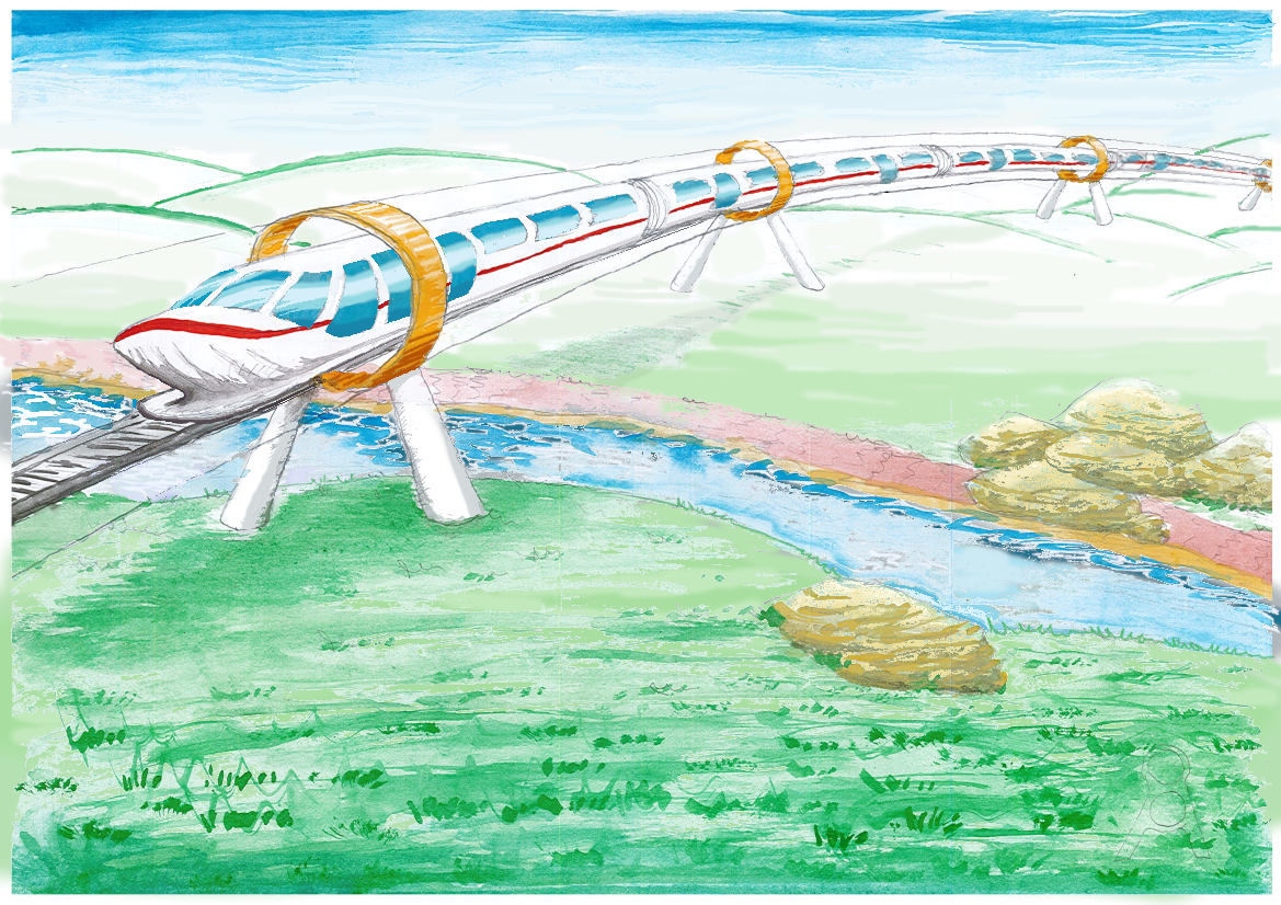
On two sections of the network, between Tokyo and Nagoya, as well as between Beijing and Shanghai, magnetic levitation (maglev) train lines are currently under construction. In the long term, the partial vacuum sealing of these tracks could allow speeds far beyond the cruising velocity of airplanes, effectively replacing air travel and making same-day round trips possible between any points on the network.
Detailed Description
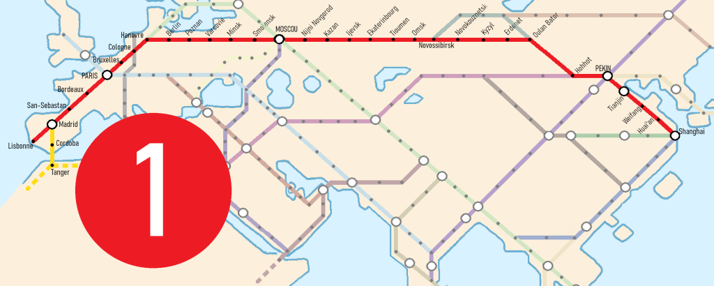
Line 1: The Eurasian
As the first segment of the new network, this line connects the European demographic hub to the Chinese demographic center.
Between these two poles, major cities aligned in a straight path through sparsely populated regions form the backbone of this highly direct route.
A modern and extended version of the Trans-Siberian Railway, it spans the entire Eurasian continent, from the Atlantic Ocean to the Pacific Ocean.
In Madrid, a planned branch would extend toward Africa via the Strait of Gibraltar.
Due to its significance and foundational role within the network, its designated color is red.
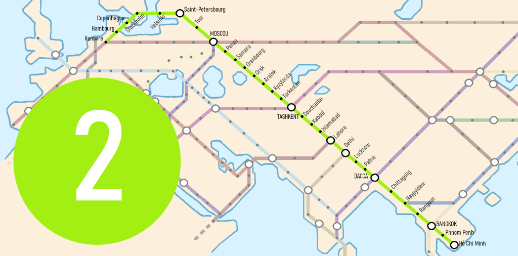
Line 2: The Forester
It connects Europe to the Indochinese Peninsula, passing through the Ganges Valley below the Himalayas and integrating the Scandinavian Peninsula into the network.
It stretches from the Baltic Sea to the Pacific Ocean via the South China Sea, with access to the Indian Ocean.
Among its thirty stations, fourteen are administrative capitals, making it a major political axis.
Linking temperate forests to tropical forests, its color is green.
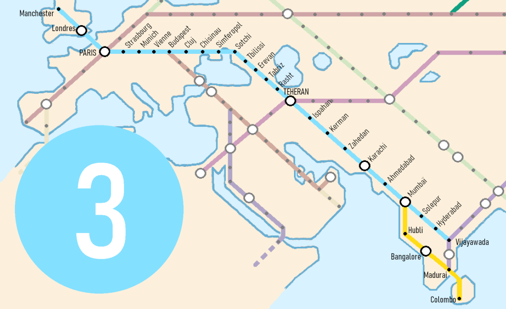
Line 3: The Maritime
This line connects the former global demographic hub, the European subcontinent, to the future one, the Indian subcontinent.
It crosses Eurasia from the Atlantic Ocean to the Indian Ocean.
From London to Chennai, its straight path grazes the Black Sea, the Sea of Azov, and the Caspian Sea.
A route could extend to the southern tip of the Indian Peninsula and cross Adam’s Bridge to reach Colombo on the island of Ceylon.
In its developed version, a western extension to Dublin is being considered.
Once a major maritime route linking the United Kingdom to India, it touches three seas and two oceans. Its color is blue.
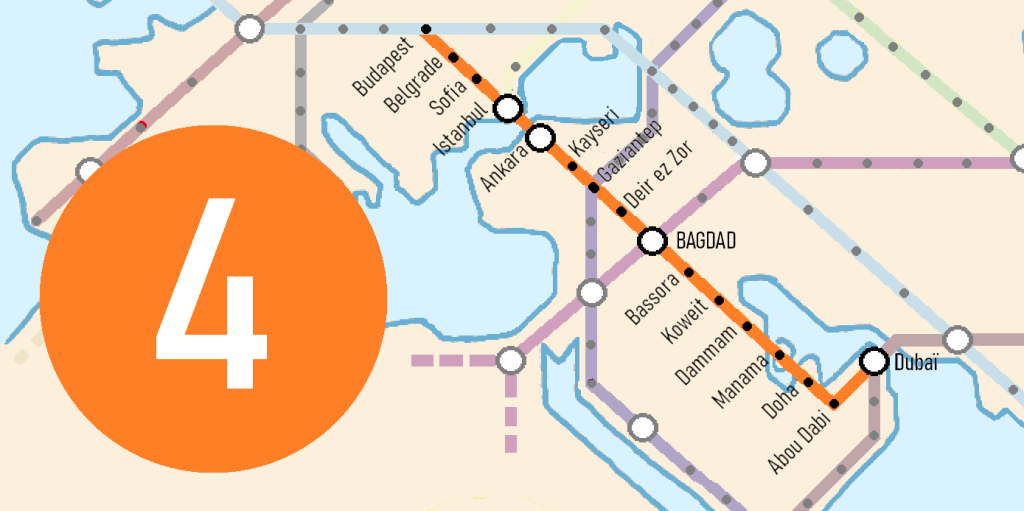
Line 4: The Middle Eastern
It connects Europe to the new dynamic hubs of the Persian Gulf.
A key station on this line, Istanbul, the largest city in Europe, is also a natural and logical gateway from Europe to Asia.
Leaving Europe via the Bosphorus Strait in a straight line, the route follows the course of the Euphrates River to its mouth, then extends to the easternmost tip of the Arabian Peninsula.
Nine of its sixteen stations are administrative capitals.
Crossing a vast desert of sand at the end of its journey, its color is orange.
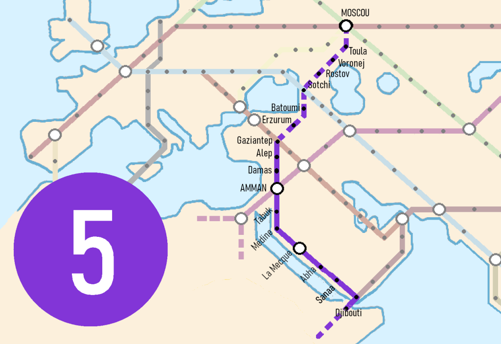
Line 5: The Near Eastern
This line completes the connection between Europe and the Arabian Peninsula in its western part.
It also provides another access point to Africa by crossing the Red Sea at the Bab-el-Mandeb Strait.
It could be extended northward to Moscow.
The route passes through historically and culturally rich locations, including the Jordan Valley, Mecca, and the ancient Incense Route.
For the density of heritage sites it crosses and the abundance of Africa to which it provides access, its color is dark purple.
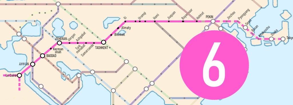
Line 6 : Silk Road
It connects the heart of China to Africa.
By drawing a straight line from Beijing to the Isthmus of Suez to reach Africa, a natural route emerges, passing between two great deserts, two vast lakes, and two major mountain ranges, intersecting all other Transeurasian lines at key stops across Central Asia.
The route of this line largely follows that of the main historical Silk Road.
The only land connection between Eurasia and Africa leads directly to its largest city, Cairo, and the many riches of the Nile.
An eastern extension to Japan via Beijing and the two reunified Koreas would be highly relevant.
A straight westward extension could be considered as far as Lagos, allowing the line to serve Africa’s two largest cities.
For its historical significance and its role as the backbone of the Transeurasian network, its color is fuchsia pink.
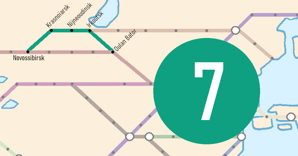
Line 7 : The Siberian
A duplication or an alternative to Line 1.
As a duplication, it would help connect vast regions to the network.
As an alternative, it offers a slightly less direct but more populated route to link Paris and Beijing.
It passes through Irkutsk, which could serve as the starting point for a potential Line 14, running in a straight line to Vladivostok via Harbin.
For the coniferous forests it crosses, its color is dark green.
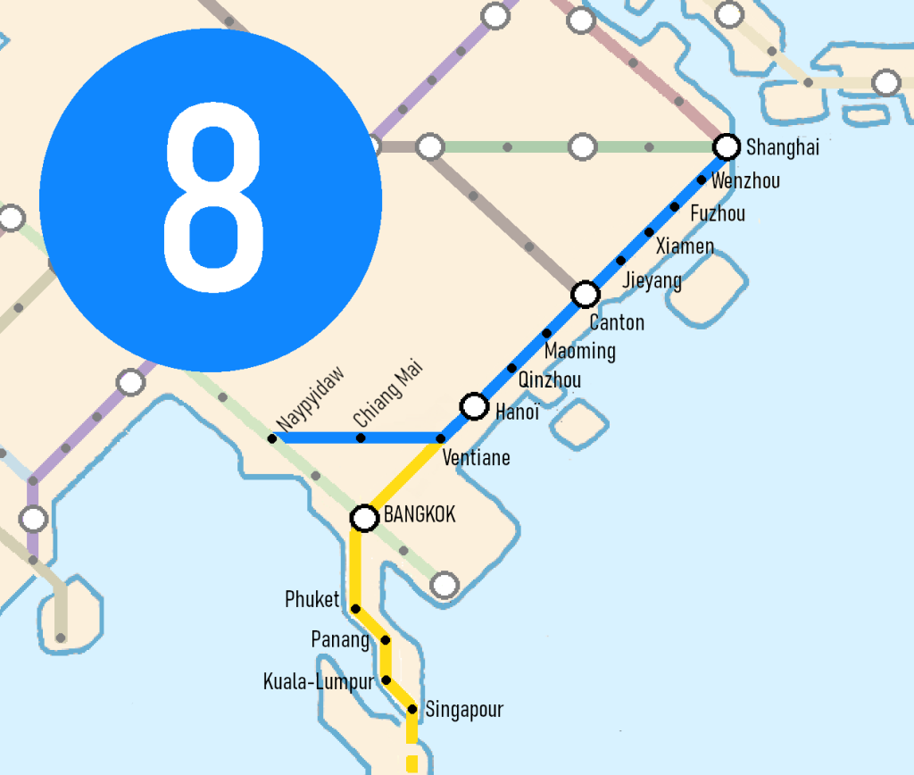
Line 8: The Pacific
It completes the network by connecting it to China’s thriving maritime façade.
The line passes through the country’s two economic hubs, Shanghai and the Cantonese megalopolis.
An extension is proposed to reach Oceania via the islands of Singapore, Sumatra, Java, and Bali.
For its route, which largely follows the coasts of the China Seas, its color is dark blue.
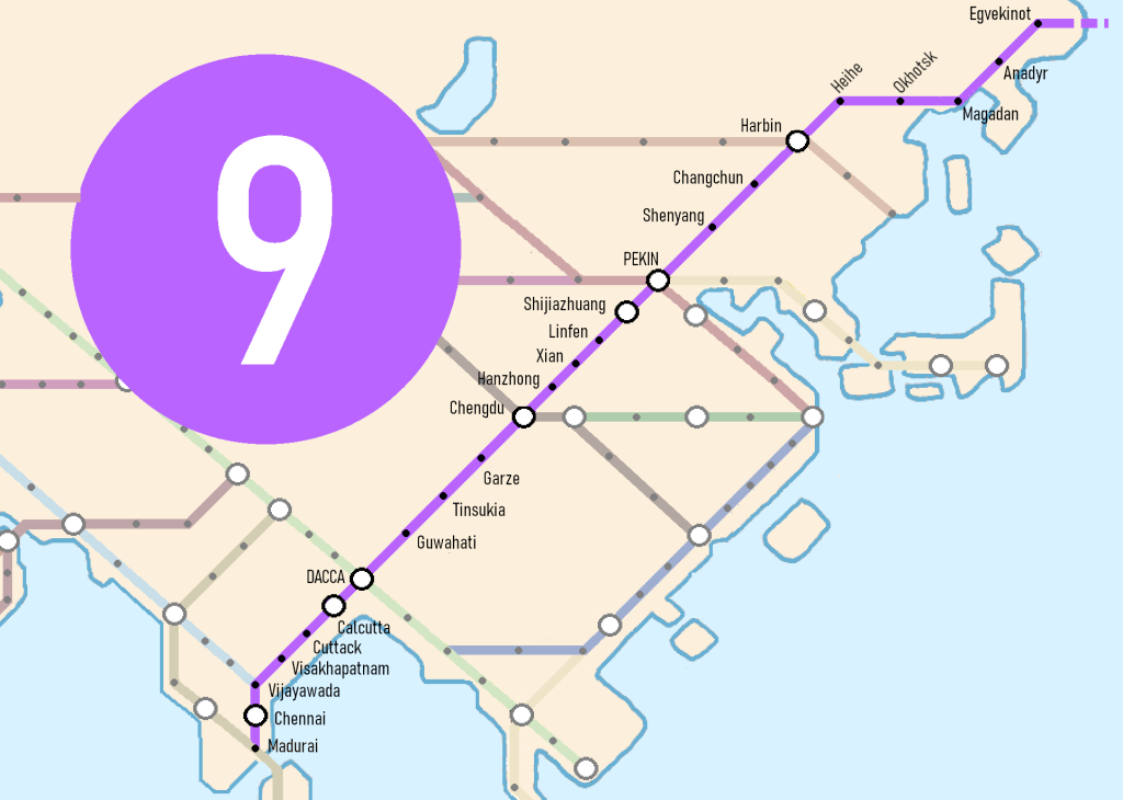
Line 9: The Amerindian
It brings China, the world’s largest current demographic and economic hub, closer to India, which is projected to be the future one.
This line represents the greatest technical challenge due to the high mountain ranges of Sichuan that it must cross.
Given the stakes in relations between these two giants, efforts can be made.
Moreover, a straight line from Beijing to the Indian Peninsula crosses the Sichuan mountain ranges at their narrowest part, where the peaks are much lower than further north.
For India and China, this line enhances their connections to the network, both nationally and across Eurasia.
If extended, this straight line could lead to Seattle in North America via the Bering Strait, thereby linking all inhabited continents by land and making Eurasia the center of the terrestrial world.
For its ingenuity, boldness, and the freezing cold of some of the landscapes it crosses, its color is light purple.
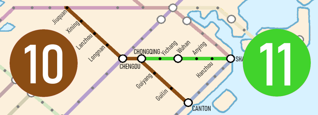
Lines 10 and 11: The Mountainous and the Fluvial
They weave a denser network over China by integrating the major cities of Chongqing and Wuhan, thus enhancing the country’s connection with the rest of the world as well as its internal links.
Line 11 follows the entire course of the Yangtze River.
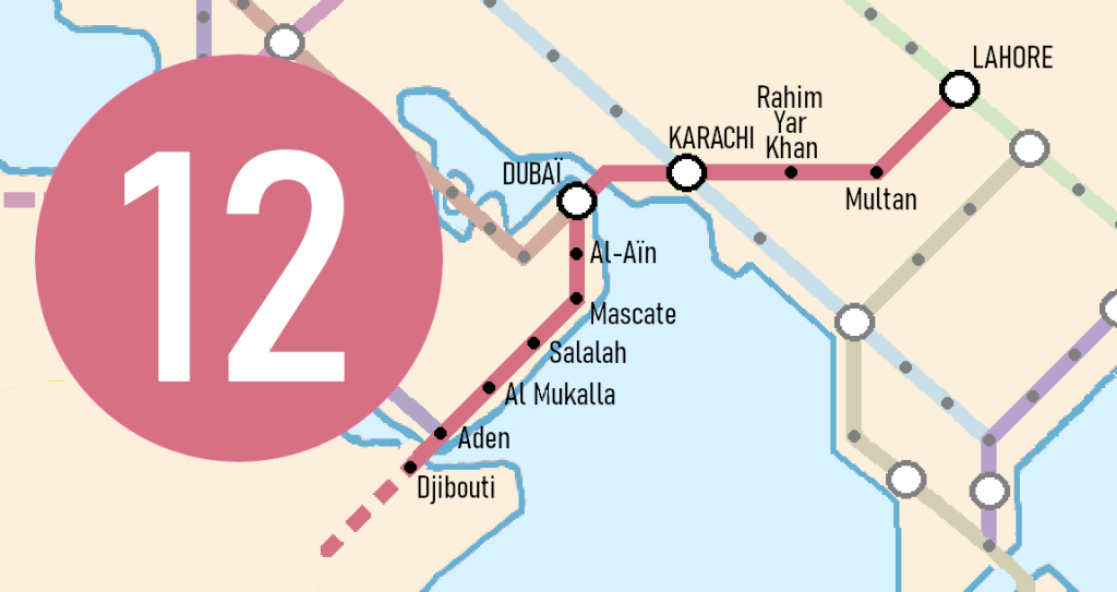
Line 12: The Asiafrican
Crossing the Straits of Hormuz and Bab-El-Mandab would create a highly direct and strategic passage from Asia to Africa.
The line runs through the densely populated Indus Valley, providing Pakistan with a highly comprehensive network and enhancing the connection between lines 2 and 3.
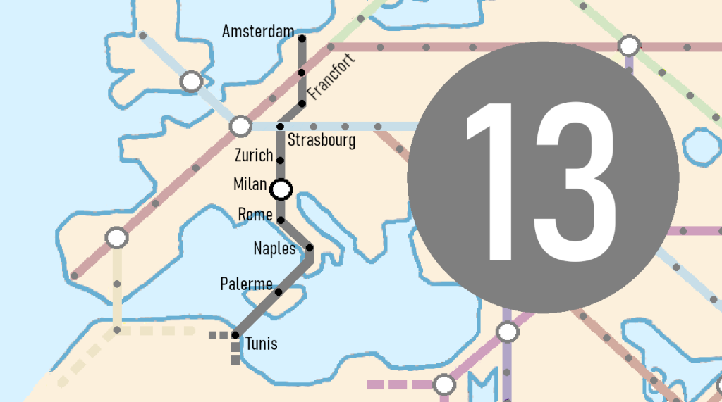
Line 13: The Western
Perpendicular to lines 1 and 3, it follows the European high density populated axe, the demographic heart of Europe, extending far into the Italian Peninsula and reaching Palermo in Sicily. If further extended, it could provide a fourth access to Africa via a nearly 145 kilometers long tunnel under the Mediterranean Sea.
Line 14: The Nordic
Its route closely resembles the very old Baikal-Amur Magistral railway, which predates the Trans-Siberian.
Following a straight line from Irkutsk to Vladivostok, it passes through the major Chinese cities of Qiqihar and Harbin.
It shortens the journey between Europeans and North Americans.
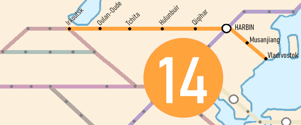
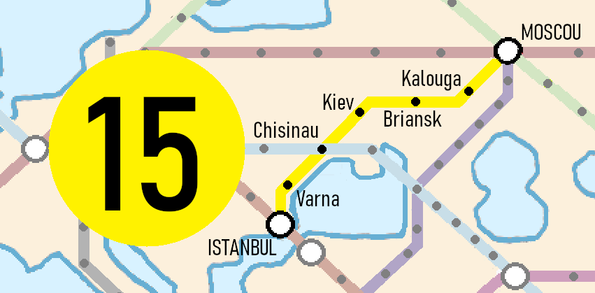
Line 15: The Transeuropean
It connects the two largest cities in Europe, Istanbul and Moscow.
If extended south to Italy by crossing the Adriatic Sea, it would link up with Line 13 and provide an interesting access route to Africa.
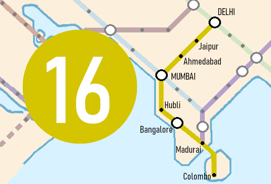
Line 16: The Indian
This line enhances both India’s internal connections and its links to other parts of the world.
It serves Sri Lanka via Adam’s Bridge.
contact : Noé BELLU
neopurpink@hotmail.com


